LPBF Releases Two Unique studies
on Hurricane Surge Movement in Southeast, Louisiana
May 15, 2020
We have all seen lots and lots of maps showing
surge flood heights from past hurricanes or forecasts of approaching
hurricanes. We all know that the level of damages and the risks to safety
are strongly dependent on how high flood waters will be. However,
these flood maps are almost always a map of the maximum flood levels during the
entire duration of the hurricane. For example, the flood map may show high
flood water in Slidell and in Madisonville, but the high water
did not actually happen at the same time, because it shows the maximum height
regardless of when it happens. So, this is a weakness of the
maximum flood maps, because it does not show how or when the water actually got
there. Therefore, LPBF conducts “surge dynamics analysis” which is simply
looking at the time-lapse sequence of surge movement over the few days that a
hurricane is affecting our coast. The time-lapse analysis reveals aspects
of surge that is generally not known, but also suggests answers to the age-old
question “what’s the worst hurricane track?”
We basically examined time-lapse for Hurricanes Katrina (tracked
east of New Orleans) and Isaac (tracked west of New Orleans) in two different
regions: Lakes Pontchartrain/Maurepas and Breton Basin (St.
Bernard and east Plaquemines Parish). In both regions, we saw
that generally as a storm approaches the coast surge builds in the same areas
regardless of the storm track. For the Lake Pontchartrain region, storm surge
tends to build in the Laplace/Frenier area, and for
the BretonBasin, surge builds along
the Mississippi River near Pointe a la Hache
or further south. Another aspect of surge movement is that, both regions
can have severe flooding when surge is moving back to the gulf.
Generally, it is implied that the surge moving inland is of greatest
concern. However, these “outflow surge” events have been catastrophic in
both areas and continue to present a major threat to both regions.
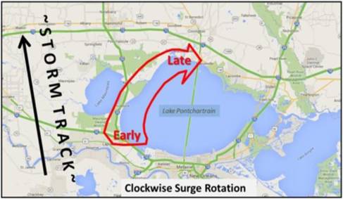
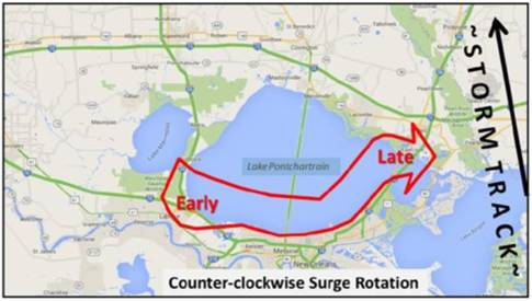
So, in the Lake Pontchartrain region, surge
movement can be described as rotating around the perimeter of the
lake. The surge always starts in the Laplace/Frenier
area, but if the storm is tracking east (Katrina) of the lake, surge moves
counter-clockwise from Frenier and toward NewOrleans and then as strong
outflow surge toward Slidell. If the
storm is tracking west of the lake (Isaac), the surge at Frenier
moves clockwise toward Madisonville and then as a weak
outflow surge toward Slidell.
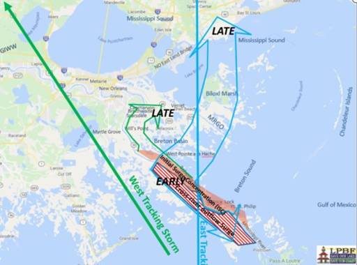
In the Breton basin, the surge starts along the river, however what
happens afterward is again dependent on the storm track. If the
storm passes to the west (Isaac), the initial surge along the river is pushed
northward along the Mississippi River levee towards Caernarvon and
Braithwaite. If the storm passes to the east (Katrina), the surge along
the river is pushed southward creating a very severe outflow surge event.
This outflow surge event is especially noteworthy because of compounding
factors. For major storms like Katrina and Camille, surge overtopped the Mississippi River levees on both the
east and west bank. At the point when the storm is just east of the river,
there are three re-enforcing influences making surge much worse, including high
surge within the river, a north wind blowing surge south, which is the same
direction of river flow. This outflow surge event has happened at
least twice with complete devastation to Lower Plaquemines parish’s east and
west bank. The interaction of the Mississippi River with surge is now
getting more attention, but generally the interaction of river flow, levees and
surge have not been well modeled or understood.
We encourage folks to review LPBF’s two
reports on surge dynamics. We believe it reveals critical information to
understand risks due to hurricane surge. However, we must also remind
everyone that every storm is different in detail, and that we should all act on
the side of caution and respect emergency directives during an actual hurricane
event.